I haven't run since the end of October. Motivation is gone. I'm not sure I'll ever be a runner again. Runs have been very few at all since summer. At least my weather is here now, so maybe I'll run a little more.
I knew it would be a bit chilly. I went with shorts, a long sleeve shirt and vest. I was thinking early on that a lack of headband and gloves might hurt me. However, by the end, with the wind at my back, I was actually quite hot.
I decided to just run a few easy miles on the Nor-Bath Trail. With such little running and freezing cold air, I thought I'd struggle greatly. I started at Bicentennial Park and ran toward Northampton. Some runners started ahead of me.
I felt nice and fresh early. I wasn't too cold. I got to the road crossing quickly. I ran easy and breathing wasn't bad, even though I'm overweight. My GPS watch doesn't work any more, so I had no idea how far I had run.
I could see the runners far up ahead. As I got closer, I saw they were walking and another runner was running. I realized I was gaining on that one. It probably pulled me along faster than I wanted.
I blew past the bundled up runner and it was a huge confidence booster. I was going to run to a paved path. However, I felt so good, so I kept going. I decided I'd run to the parking lot, right before the road crossing.
I did that and then turned to head back. It seemed slightly uphill coming back. I definitely slipped off a bit now, but overall it still wasn't too bad. I passed the bundled guy coming back. I had to laugh, as I was in shorts and he was freezing.
I was getting hot now that the wind wasn't at my back. In open field sections, it had been a little cold earlier. I unzipped the fleece too.
It seemed to take forever to get to the road crossing. I could see it for a long time. I was thinking a little, but getting bored. Finally, I was to the road and over it.
I was happy to see the park. Before I knew it, I was done. It was nice not having my watch work. I had no idea of the time. I think that helped me enjoy the run more. Maybe if I do that some, I'll run more often.
I mapped things at home and it was just under 4 miles. I was shocked I ran so well for that long. It was easy rail trail, but still. I bet my pace wasn't terrible either. I doubt I'll ever be a runner again, but I should run more frequently.
3.7 miles
Saturday, December 10, 2016
Monday, October 31, 2016
Running Again
I knew some personal issues affected my running. I thought the weather was the biggest factor in my lack of desire to run. However, the weather turned favorable some time ago, including the recent awesome fall colors. Still, I had not run since the end of July.
Work is partially getting in the way. I certainly have time to run if I really wanted to, but I have nowhere near as much as I used to. Today, I don't work until 4 PM, so I dragged myself out for my first run in a long time. Even getting out there today took some effort.
Part of that was knowing how out of shape I am and will be. I knew it would be a struggle. Still, I headed to Jacobsburg before lunch. I needed somewhere easy. I decided to park in the main lot, run to Sober's Run and complete that loop clockwise this time.
It was a nice and comfortable day. I brought a sweat by the end, but I did enjoy the weather. I headed out and was winded pretty early. The air was just slightly cold and I'm not used to it.
I chose this route because it was kind of short and has a lot of singletrack. I suspected some of the leaves would still be popping as well. I was a bit happy to get on the singletrack, but was kind of bored before that. I certainly wasn't enjoying running. I was still struggling to breathe.
Some of the parts along the creek were pretty, but it was kind of hard to enjoy. I came out on the main path after a bit. I was right in front of two horses. I was glad they went the other way. I would've pushed way too hard if they followed me up the hill.
I decided to run in the reverse direction from usual. This was because I knew I couldn't make it up the steeper hill. I also knew this long gradual hill would be a struggle. I battled up it. The scenery was pretty, but my running was not. I just continued to move forward though.
One problem is I don't go this direction much, so I wasn't quite sure how much farther I had to go. At one point, my burning lungs had just had too much. I walked uphill for a minute or so. I recovered quickly though and then ran again.
I actually wasn't far from the top and kind of kicked myself for not pushing through earlier. I was thrilled to be at the top and running down the powerline. There was a nice blend of orange, yellow and red on the trees here. It was pretty sweet. I wasn't anticipating so much color.
Heading toward the small lot was a tunnel of yellow. It was even more beautiful on the singletrack across the creek. My watch had froze and I wanted to fix it, but I was worried I'd encounter the horses again. My shoelace had been untied since the hill too.
My breathing had been good though ever since coming downhill. I cruised along on the beautifully colored singletrack. Eventually, I came to the horses and stopped to let them pass. It was a good spot.
Running over rocks covered with leaves was tricky. I managed to do it though. I was back to the road crossing in no time. An 18 wheeler came by. That was bad timing. I was relieved to get back on the trail and be heading home.
I passed a dog walker after alerting him of my presence. The dog barked like crazy. I then had fixed my watch and saw I was over 4 miles. I came on in and finished up right back at my car.
It was good to sweat and see some scenery. However, it wasn't much fun actually running. I just have lost so much interest in running. Other than running with people, I don't see how I'd get out there much any more. I do need to try at least a 2 or 3 times a week though.
I'm backpacking on my day off later in the week. That, I'm enjoying much more. It is probably the route I'll be going down the road. I don't see how I could ever do an ultra again. It is just too much training.
I would like to run again on Friday and maybe travel somewhere knew. Different trails are about the only running thing that interests me at the moment. Maybe living in a new location would help with that, but I'd probably just backpack more.
Friday, July 29, 2016
Super Muggy Repeats
I haven't run in some time. The weather has been crazy stupid. I asked Angie about running at Katellen last night. She said tonight might work. She told me last minute and I rushed out there. She started a loop before I got there.
It was crazy hot and muggy. The only thing that made it bearable was that it looked like storms were coming through. Luckily, they never did. I went with a sleeveless shirt and was soaked.
Angie ran ahead to start and I followed behind. I was breathing heavy early on. The hill wasn't steep, but it was uphill and the humidity bothered me. We ended up hiking a lot of the way. I ran when she did and hiked when she did. She blasted through the first loop, but took it easy now. That was good for me.
There was one tent in the camping area at the top. I didn't notice if there were any people at the shelter or not. We rested a bit and headed down.
Angie was ahead, but I felt good and she seemed to be going a little slow. I ran hard for a bit, but that was enough. I decided to slow after that. She went by. I caught back up when her pants began to slide down and she had to tie them. I finished a little ahead of her, but not by much.
We rested a bit and it was on to the second loop together. Again, I mostly followed her up. My breathing was labored for sure, but a little better this time. Near the top is a steep part. I told her I could run it and I took off. This did burn my lungs, but I made it.
We headed back down again. I passed her again with some fast running. I stayed steady and ended up ahead of her this time. The downhills wore out my quads a bit.
It was now on to the last loop. We were talking about running up it, so I was determined to run as much as I could. I guess I have the uphill course record here. I don't know, as I don't recall trying to run it fast.
I pushed hard this time though. I noticed some people camping in a tent just off the trail. I never saw anyone there before. I went hard running when I could. I was trying to take big breathes so I could go longer.
I ran a lot, but had to walk once it became like steps. I thought Angie was on my heels, but I actually couldn't see her at all. I was hurting back. I pushed too much.
My breathing wouldn't recover and my entire stomach hurt. I hiked most of the steps. I then ran a few other parts. Every time I ran, my breathing got worse. I sure can't run too much of this trail during the summer. I battled through it though and was eventually at the top (not even close to the CR).
I waited for Angie at the top, thinking we'd run down together. I let her lead and she was completely gone. It was getting very dark in the trees. I was cautious and still tripping over stuff. She was cruising. I saw her around the bottom of the steps, but never again. Even on the flatter part, I was careful.
This was a short run, but tough with the weather. I need to force myself out there a little more. I know I won't be running like I would if it was cool out though.
I'm not sure when I'll run again. I'm working all weekend. I may camp and backpack during the week. Maybe I can run while camping.
5.72 miles - 1:37:02 (16:59 pace) 1660 feet of elevation gain
Thursday, July 21, 2016
Frustrating Hickory Run Run
I haven't run since my trip to Ithaca. It has been unbearably hot and humid. It did cool down over the last few days. My dad and I were camping at Hickory Run State Park, so I opted for a run there.
 It was nice and I had shorts and a sleeveless shirt on. That said, I was still sweating a bit in the afternoon. I'd take this weather all summer for sure though.
I've run a lot of this park and haven't been too crazy about it. There wasn't much cool singletrack. That seems to be an issue for a lot of Pocono State Parks. I decided I would try the northern end of the park.
Since my dad was there, I had him drop me off at the boulder field. I'd then run about 10 miles back to the trailhead he was going to hike from. That would give me something new.
Earlier in the day, I took my hammock and relaxed out on the Boulder Field. It is quite long and very rocky obviously. I couldn't run on it, but I moved very fast. It took me like 8 minutes and 40 seconds to complete.
I followed what looked like a trail from it. However, it lead to a fire ring. I didn't quite go out far enough. Luckily, this was an evergreen forest with no understory. Therefore, I bushwhack my way through to the trail. For a short bit, I was thinking I may have to backtrack.
I did come to the trail though and then started going left. After a bit, I realized I was just looping back to the parking area of the boulder field, not going the way I wanted. I turned back around.
This park of the Stone Trail had been boring. It was a wide doubletrack, mostly used by snowmobiles in the winter I guess. I got to a turn and things got much worse. It became singletrack, but was crazy overgrown.
Some of the bushes were waist high. I could hardly find the trail. I mostly hiked through this part. I became so frustrating and was yelling frequently. This might've been a nice trail if maintained or used, but it was overgrown now.
It seemed like forever, but eventually I came to the the end of the Stone Trail. I came out to what looked like another snowmobile trail. This was the Fourth Run Trail. It is almost 5 miles long.
 I had a decision to make. I could take the dirt and paved roads back to the car or try to go through this trail. Since most trails here have disappointed me, I figured this one likely would too. It did cross a stream several times, but who knows if anyone uses it. I didn't want to find out they don't have to turn around after several miles.
I opted for the road, even though I didn't like that idea. At least I knew where I was going. It was now a dirt road. Cars were on this though. Most were careful, but the first one came flying by. I crossed under the Northeast Extension of the Turnpike. That was cool.
Around 3 miles, I got back to pavement. I was about 7 miles into the run or so. I followed the pavement out to the Daddy Allen group camp and another camp. No one was there and I had this paved road to myself. I kept checking the map.
Although this was road, it actually turned out to be the coolest part of the run. The road went along Hickory Run, which was a beautiful waterway. It was surrounded by blooming Mountain Laurel. There were some cool rocks too. It has some hills, but mostly was downhill.
After a slow start, hiking a lot, I was now running a lot. I was making up time at least. The first 4 miles had taken me over an hour. Now, I was coming closer to being on pace to actually finish the run in 2 hours.
There were a bunch of cool rock waterfalls. Then, there was an old chapel right by the main road through the park. I headed north on that. I figured it was uphill and it was.
 I thought about taking one of the trails across the road. I was unsure their condition though. I played it safe and went with the road. This was only 2 miles or so, but it seemed to take forever. I ran some and hiked some.
I used the contours on the map to figure out where I was. I was happy when I saw I was going uphill near the highest point. Then, it was mostly downhill to the trailhead.
My dad was on a chair reading. He was surprised that I was running on the road. The trail across the street looked overgrown too. It was probably good choice to stay off the trails. Road running was very frustrating, but at least I got some miles in.
I'm not sure when I'll run again. I'm working all of the next three days. I'm off much more next week. If it isn't too hot, I'll try to get out. I'd love a 15-20 miler somewhere. I need some climbing too.
10.03 miles - 2:04:00 (12:22 pace) 472 feet of elevation gain
 It was nice and I had shorts and a sleeveless shirt on. That said, I was still sweating a bit in the afternoon. I'd take this weather all summer for sure though.
I've run a lot of this park and haven't been too crazy about it. There wasn't much cool singletrack. That seems to be an issue for a lot of Pocono State Parks. I decided I would try the northern end of the park.
Since my dad was there, I had him drop me off at the boulder field. I'd then run about 10 miles back to the trailhead he was going to hike from. That would give me something new.
Earlier in the day, I took my hammock and relaxed out on the Boulder Field. It is quite long and very rocky obviously. I couldn't run on it, but I moved very fast. It took me like 8 minutes and 40 seconds to complete.
I followed what looked like a trail from it. However, it lead to a fire ring. I didn't quite go out far enough. Luckily, this was an evergreen forest with no understory. Therefore, I bushwhack my way through to the trail. For a short bit, I was thinking I may have to backtrack.
I did come to the trail though and then started going left. After a bit, I realized I was just looping back to the parking area of the boulder field, not going the way I wanted. I turned back around.
This park of the Stone Trail had been boring. It was a wide doubletrack, mostly used by snowmobiles in the winter I guess. I got to a turn and things got much worse. It became singletrack, but was crazy overgrown.
Some of the bushes were waist high. I could hardly find the trail. I mostly hiked through this part. I became so frustrating and was yelling frequently. This might've been a nice trail if maintained or used, but it was overgrown now.
It seemed like forever, but eventually I came to the the end of the Stone Trail. I came out to what looked like another snowmobile trail. This was the Fourth Run Trail. It is almost 5 miles long.
 I had a decision to make. I could take the dirt and paved roads back to the car or try to go through this trail. Since most trails here have disappointed me, I figured this one likely would too. It did cross a stream several times, but who knows if anyone uses it. I didn't want to find out they don't have to turn around after several miles.
I opted for the road, even though I didn't like that idea. At least I knew where I was going. It was now a dirt road. Cars were on this though. Most were careful, but the first one came flying by. I crossed under the Northeast Extension of the Turnpike. That was cool.
Around 3 miles, I got back to pavement. I was about 7 miles into the run or so. I followed the pavement out to the Daddy Allen group camp and another camp. No one was there and I had this paved road to myself. I kept checking the map.
Although this was road, it actually turned out to be the coolest part of the run. The road went along Hickory Run, which was a beautiful waterway. It was surrounded by blooming Mountain Laurel. There were some cool rocks too. It has some hills, but mostly was downhill.
After a slow start, hiking a lot, I was now running a lot. I was making up time at least. The first 4 miles had taken me over an hour. Now, I was coming closer to being on pace to actually finish the run in 2 hours.
There were a bunch of cool rock waterfalls. Then, there was an old chapel right by the main road through the park. I headed north on that. I figured it was uphill and it was.
 I thought about taking one of the trails across the road. I was unsure their condition though. I played it safe and went with the road. This was only 2 miles or so, but it seemed to take forever. I ran some and hiked some.
 I used the contours on the map to figure out where I was. I was happy when I saw I was going uphill near the highest point. Then, it was mostly downhill to the trailhead.
My dad was on a chair reading. He was surprised that I was running on the road. The trail across the street looked overgrown too. It was probably good choice to stay off the trails. Road running was very frustrating, but at least I got some miles in.
I'm not sure when I'll run again. I'm working all of the next three days. I'm off much more next week. If it isn't too hot, I'll try to get out. I'd love a 15-20 miler somewhere. I need some climbing too.
10.03 miles - 2:04:00 (12:22 pace) 472 feet of elevation gain
Friday, July 8, 2016
Robert H. Treman State Park Run
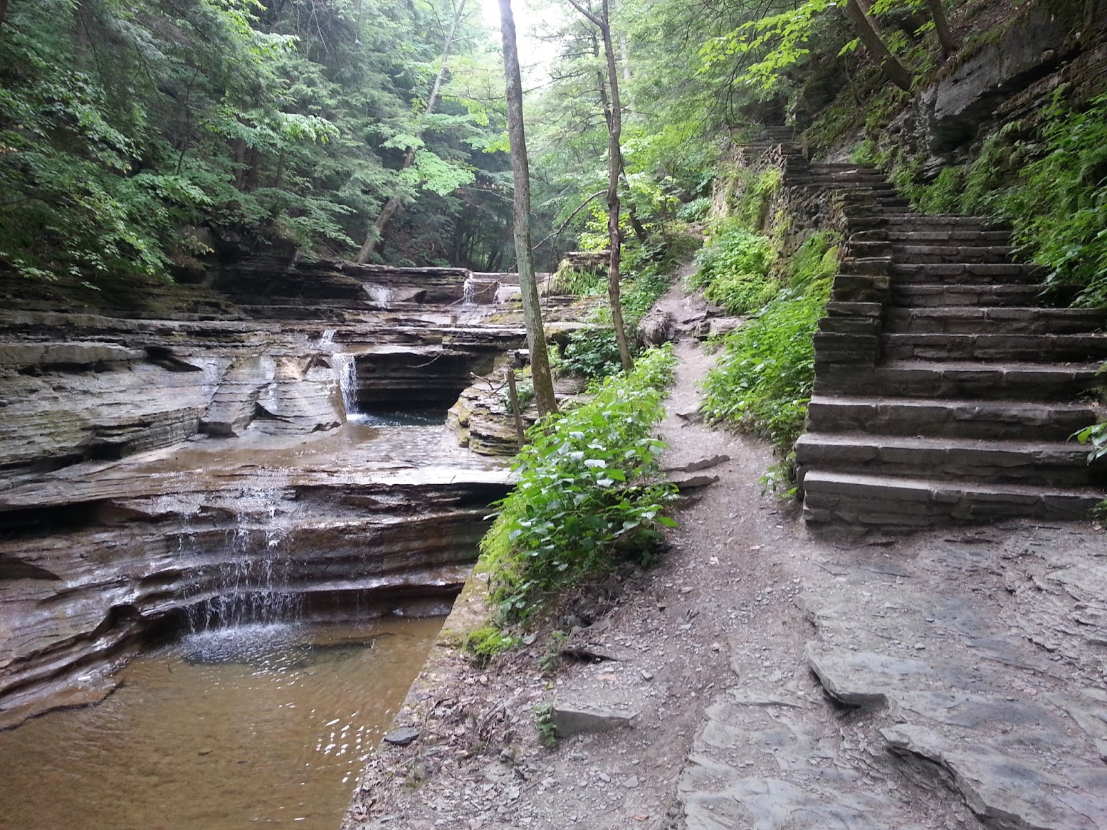
Yesterday's run at Buttermilk State Park was awesome, but I knew today would be even better. I had already hiked the gorge through Robert H. Treman State Park and it was stunning. It is so steep and the walls, steps and waterfalls are unbelievable.
 I took awhile to get out of bed. I had to pack all my camping gear up and get out to run. I started around 9:30 in the morning and it was already crazy humid. I had on a tank top this time. Everything was soaked as usually though. I thought summer was nice until the humidity of the last few days. It has just been stupid.
I took the loop in the opposite direction today. I went up the rim trail first. It begins by the cabins. Then, there is some tough climbing. The first person I saw was the guy hiking at Buttermilk Falls State Park yesterday. That was quite funny.
This trail was rather quiet. I guess I didn't even realize that until later. I did enjoy it though. The lower gorge area here isn't as amazing as the upper gorge. Where the two sections met, I had to do this crazy stair climb. It was brutal. It was exposed to the sun and so hot.
 I was able to run quite a bit after that. I would've run even more of the trails if they were so humid. They had few rocks and the elevation wasn't killed. The humidity surely killed me though.
It seemed quick that I was off the Rim Trail and on to the Old Mill. I followed this trail out a bit more. This was some nice singletrack. I think it was the old CCC Trail. If not, then it was the Finger Lakes Trail again.
It said a bridge was out, but I didn't get there. I decided that there was more high grass than I liked. I forgot to put on bugspray. I turned around before mile 3.
I was thrilled to get on the Gorge Trail again. The beginning of it is just crazy. The stone path goes right along the water and there are huge rock walls. Then, it dips down the waterfall. It is truly unbelievable.
 A bunch of people were in this area. The Gorge Trail was definitely more packed, as it was later in the morning too. I had been moving well, but the scenery slowed me. I stopped for a lot of photos.
This was simply amazing and the pictures don't do it justice. However, I did expect these gorge sections to be longer. It was less than a mile each at both parks. Even that short of a distance is worth the price of admission though.
When I got to the bottom of the steps, I saw a mother and daughter looking at a map. I told them the cool stuff was straight ahead. Now, I was mostly on singletrack. There were some cool gorge segments here and there.
 It was still super humidity. I ran a good amount, but not as much as I would've in normal conditions. I took many pretty photos too. I said "good morning" to many of the people. I loved that there were plenty of people on the trails, but it wasn't overcrowded.
I ran along and before I knew it, I was done with the loop. I had nearly 6 miles and a ton of fun. It was another great short run this summer. I'm so grateful as I've seen so much stunning stuff.
I will definitely be back here. I might come in the fall, when the colors change. If not, I'll likely signup for the Cayuga Trails 50.
I'm taking tomorrow off. On Sunday, I'll run again. A group is going up to Mt. Tammany and I hope to join them.
5.7 miles - 1:29:38 (15:44 pace) 968 feet of elevation gain
Buttermilk Falls State Park Run (Thursday)
I start work next week. I decided that I want to take another camping trip before that happens. I've been wanting to go to Ithaca for awhile, so I did just that. I camped and hiked last night, but today was my first run.
I'm staying at Robert H. Treman State Park. I hiked there last night and it was amazing. Buttermilk Falls State Park is only a few miles down the road. Both have terrific gorges and waterfalls. Added on to that is that beautiful stone walls were built around the trails. They are simply stunning.
 I waited for a thunderstorm to pass. The morning had seemed a little cool, but after the storm, it was just brutal. It was crazy humid. I wore shorts and short sleeves. I was drenched by the end.
Right near the parking lot is the swimming area. It is currently closed though. They haven't had much rain in weeks and the lower falls are barely a trickle. I ran a little in the beginning, up some steps. The stone stairs around are amazing.
The whole beginning in stunning. I stopped for photo after photo. I even spotted some fish. I was running along the Gorge Trail first. This trail was beautiful, but over shortly, in less than a mile.
Then, it was on the Bear Trail. This is more of a normal woods singletrack. It is very pretty and the trail is smooth. If it wasn't located next to the trails of the gorge, it would be a great trail. I did enjoy running it.
This was a little more runnable. However, the humidity was slowing me down. My photo and GoPro were getting wet when I kept picking them up. This trail didn't last long either.

There was a short road run, then it was on the Lake Lehman Trail. It looks around a lake. The lake was mostly dry. Some of the trail was woods, other parts were stone. It wasn't as cool as the lower gorge, but it was still pretty.
Partway around the loop, I saw the Finger Lakes Trail. This is a fairly long distance trail. I once tried to find it near Watkins Glen, but had no luck. This section of singletrack was pretty.
I was surprised to see a couple walking their dog. I figured there was a road nearby and I soon got to it. I didn't want to run on the road, so I headed back.
I finished up the loop around the lake. I saw a few people. One time, I tripped near some people and nearly hurt myself. It wasn't long and I was through the lake trail.
I headed back. Now, I'd have a lot more downhill than uphill. I had to take the Bear Trail back. I saw a woman running on it. For the most part, the trails were quiet throughout the week. There are a lot of people missing out.
 Instead of taking the Gorge Trail back, I went across the way to the Rim Trail. This trail was pretty, but there weren't really any views. It was a nice run though. It did have some uphill that I had to hike. I sure was tired and soaked by this time.
On a descent, I saw this guy with his phone. I saw him earlier and I would see him again in the future too. I lost the trail a little, but got back in no time. I finished up back at my car.
This was a terrific run and I enjoyed it as much as I thought I would. The humidity couldn't even dampen the amazing scenery. It was all I could've asked for and definitely worth the trip. I want to run the 50 miler at these two parks next year.
Tomorrow, I'm going to run at Robert H. Treman State Park. I'm going to loop in the opposite direction of my hike last night. I'll take the Rim Trail first, then the Gorge Trail back.
5.51 miles - 1:28:57 (16:04 pace) 837 feet of elevation gain
I'm staying at Robert H. Treman State Park. I hiked there last night and it was amazing. Buttermilk Falls State Park is only a few miles down the road. Both have terrific gorges and waterfalls. Added on to that is that beautiful stone walls were built around the trails. They are simply stunning.
 I waited for a thunderstorm to pass. The morning had seemed a little cool, but after the storm, it was just brutal. It was crazy humid. I wore shorts and short sleeves. I was drenched by the end.
Right near the parking lot is the swimming area. It is currently closed though. They haven't had much rain in weeks and the lower falls are barely a trickle. I ran a little in the beginning, up some steps. The stone stairs around are amazing.
The whole beginning in stunning. I stopped for photo after photo. I even spotted some fish. I was running along the Gorge Trail first. This trail was beautiful, but over shortly, in less than a mile.
Then, it was on the Bear Trail. This is more of a normal woods singletrack. It is very pretty and the trail is smooth. If it wasn't located next to the trails of the gorge, it would be a great trail. I did enjoy running it.
This was a little more runnable. However, the humidity was slowing me down. My photo and GoPro were getting wet when I kept picking them up. This trail didn't last long either.
There was a short road run, then it was on the Lake Lehman Trail. It looks around a lake. The lake was mostly dry. Some of the trail was woods, other parts were stone. It wasn't as cool as the lower gorge, but it was still pretty.
Partway around the loop, I saw the Finger Lakes Trail. This is a fairly long distance trail. I once tried to find it near Watkins Glen, but had no luck. This section of singletrack was pretty.
I was surprised to see a couple walking their dog. I figured there was a road nearby and I soon got to it. I didn't want to run on the road, so I headed back.
I finished up the loop around the lake. I saw a few people. One time, I tripped near some people and nearly hurt myself. It wasn't long and I was through the lake trail.
I headed back. Now, I'd have a lot more downhill than uphill. I had to take the Bear Trail back. I saw a woman running on it. For the most part, the trails were quiet throughout the week. There are a lot of people missing out.
 Instead of taking the Gorge Trail back, I went across the way to the Rim Trail. This trail was pretty, but there weren't really any views. It was a nice run though. It did have some uphill that I had to hike. I sure was tired and soaked by this time.
On a descent, I saw this guy with his phone. I saw him earlier and I would see him again in the future too. I lost the trail a little, but got back in no time. I finished up back at my car.
This was a terrific run and I enjoyed it as much as I thought I would. The humidity couldn't even dampen the amazing scenery. It was all I could've asked for and definitely worth the trip. I want to run the 50 miler at these two parks next year.
Tomorrow, I'm going to run at Robert H. Treman State Park. I'm going to loop in the opposite direction of my hike last night. I'll take the Rim Trail first, then the Gorge Trail back.
5.51 miles - 1:28:57 (16:04 pace) 837 feet of elevation gain
Sunday, July 3, 2016
J-burg Night Run
Sue set up a night run at Jacobsburg to prepare for the Ragnar Relay they are doing. I'm not a huge fan of running there, but I love the idea of night runs. There were 6 of us there.
Christina wanted to start early. We rode over, since they only allowed us to park a limited number of cars in the lot. It was cool that they gave us permission. I wasn't going to run until the main group showed, but I changed my mind and decided to run with Christina.
We started off doing the main loop. She's starting to get to know it, so I kind of let her lead. It was fun to drop back a little. My watch didn't get a signal right away and it became quite frustrating throughout the first loop.
I haven't run with Christina, so it was good to chat and catch up. It made things easier, but still Jacobsburg always seems mentally long for me. At least the singletrack was fun.
The real challenge for me is that I don't run for miles and miles any more. I basically hike a lot in between running. We ran the entire loop and 6 straight miles of running was a challenge.
The powerline was slow and tough for both of us. It reminded me of how out of shape I am now. It was good to get up it though.
Then of course there was nice descent. We heard a bunch of loud music. I guess from a nearby house. That was interesting.
I didn't realize that she usually goes along the creek, so we did that. I love that section anyway. There was a lot of horse crap throughout the run.
She wasn't quite sure on some of the turns, but we made it back okay. It was a solid time, as it took an hour. I was amazed at how labored my breathing was early, but then good later on.
We had to wait half an hour for everyone else to show up. It was nice out, but humid, so my shirt was soaked. I decided to change, but only had a light weight long sleeve. I rolled the sleeves up and it wasn't too bad.
I also dropped my vest. It was making me hot and I was drinking any water any way. It was getting dark now, so it was a good thing I had my headlamp, like everyone else.
Ryan led the way at the start. I chilled in the back, talking with Sue. I was in no rush. She feel back a little on the first gradual hill, but that was fine with us and we hiked some.
The singletrack was a little interesting in the dark. Of course the headlamps helped some. I talked with Ryan a bit about racing. We haven't run in awhile.
We stopped for a beautiful pink sky. It was still light out, but dark back in the woods. Back into the woods we went. There was a lot more singletrack. Christina was now leading us.
I was starting feel quite crappy. It was just too much running for me at the moment. Plus, I ran yesterday. I'm in terrible shape now. I don't care much, but I was paying for it.
We were even at the powerline and I wanted to walk. The heel that I injured in Moab started bothering me. I was glad we hiked up the powerline. However, I was slow as I had no energy. I was hurting too.
Then, we got to the top and I got my second wind. I felt cool and didn't want to coast around. I wanted to be done with the run, so I passed Ryan and Christina and starting flying downhill.
It was kind of fun and kind of creepy. I was well ahead of everyone and running through the dark woods. My headlamp kept sliding down my head, so I just carried it.
The fireflies were neat. They brightened up the darkness. I didn't want to do the singletrack, so I just turned before it. Nice and smooth running.
I couldn't want to get over the bridge and near the road. That didn't take too long. I was starting to tire, but almost done. When I did get to the road, I didn't want to deal with cars. I blasted through that and back on the trail.
It wasn't long and I was back the parking lot. I was beat, tired and sore. It has been awhile since I did 12 miles. I also can never handle the Jacobsburg stone. It sure beat up my feet and calves. I waited a few minutes and everyone came back.
I am sore, but was happy with the run. It was good to run with others. I need some longer runs every now and then too.
Tomorrow is definitely off. I'd like to do hills on Tuesday (maybe at Trexler). Later in the week, I'm camping in Ithaca. I can't wait to run along the falls and gorges. It should be thrilling.
Loop 1 About 6.1 miles and an hour (GPS data was incorrect)
Loop 2 6.15 miles - 1:10:38 (11:29 pace) 370 feet of elevation gain
Saturday, July 2, 2016
Smile Run
The Delps Trail stone steps repeats crushed my calves. They never get sore any more, but they've been that way now for two days. I guess it was an amazing workout. I felt like running again today though. I figured I'd stick to flatter stuff.
It was a nice and cool day. Shorts and a short sleeve shirt were great. Still, I was sweating some of course and huffing an puffing a bit.
I decided that I wouldn't run on a true trail. Instead, I'd hit the D&L at Cove Road. With the cliffs and river, it almost feels like a nature trail. The plan was for 6 miles.
They have added more parking there and the trailhead has become crazy busy. There are tons of rafters using the water and parking in the lot. I found a space and took off for my 6 mile run though. The plan was 3 miles out and back.
The cutest thing happened in the beginning. A kid of maybe 5 or 6 years of age saw me running. He was starting his walk with his family. He started running along side me. It was funny and I tried to encourage him a little and said "good job" after our brief encounter.
The trail is certainly never busy, but there were quite a few bikers on it and walkers as well. I did see some runs after I was done, but I'm often surprised I don't see more people running on it.
I took it nice and easy. I cruised along. It was a gradual uphill to start. The trail is pretty and it was a great day. However, I just still can't take easy trails. I think the issue is my mind doesn't have to focus on rocks and such, so it wanders.
The first 15 minutes took forever. It felt like 45 minutes. I didn't even look at my watch that much. I'm sure being heavy isn't helping me feel good while running either.
It was good to get to 1.5 miles, but I was still moving slow. I noticed the Mountain Laurel starting to bloom. They should be great in a week or so. Maybe I can head up to Jim Thorpe then.
Getting to mile 2 was good as well, but still seemed to take longer than it should. I was glad I only committed myself to 6 miles. I figured that point would be near where the horses are. I didn't notice them today, but I did end up turning around near that spot.
There was a cute woman biking with her kid just before the turn around. I realized the run would take less than 55 minutes. Now, I would be doing a little more downhill, although the trail is generally flat.
I just focused on mile 4. I got there and was feeling okay. I was keeping a pretty consistent pace. I then got past that and on to mile 5. I couldn't believe how busy the river was. A jet ski provided a distraction.
The final mile was basically downhill. My pace got a little faster and I cruised on in. Since the run is a curve, it is actually longer on the way back, so I went a little over 6 miles. I was happy to be done.
I was going to give this run a standard name. Then, I looked at the map of it and it was almost a perfect curve. It reminded me of a smile, which was perfect since it was a good day and a good run.
I'll see if my calves feel better tomorrow. They didn't hurt during the run, but they remain sore at other times. I'm meeting up with Sue and some other people. We are running Jacobsburg at night. I figure I'll probably do 10 miles. It is cool that we got permission from the park and I guess the police. I'm always up for a night run and haven't done one in some time.
6.08 miles - 53:48 (8:51 pace) 169 feet of elevation gain
Thursday, June 30, 2016
Up and Down the Rock Steps
I wanted to get some crazy repeats in today. I know Angie could use some too. We decided to head to the Delps Trail, for the toughest climbing around. The plan was to go up and down maybe 4 or 5 times. I haven't been there in like two months.
It was super hot. I wore a sleeveless shirt and was soaked very early on. Toward the end, my shorts got wet too. I'm definitely not used to the humidity at this point in the year.
My biggest concern was realized when we got to the trailhead. It was starting to get a little overgrown 2 months ago. However, I never expected it to be as crazy as it was. It is clear that almost no one uses the trail from the bottom. It was a haven for ticks. I don't think we came across any thankfully.
I had to lead, as Angie was concerned about ticks and the potential for rattlesnakes. I was less concerned about snakes, mainly because I've still never seen one. It would be a decent place for them to be at though.
I ran through the high grass leading the way. I knew the running wouldn't last very long and it didn't. Eventually, we were hiking. Then, we got to the steepest part, the stone steps. My legs were burning and so were my lungs. I wasn't ready for this.
Angie came prepared with water, a vest and poles. I brought nothing. My plan was to drink from the spring. We got to the spring and it was completely dry. I was screwed, as I didn't want to go back down through the high grass until we were done. Angie did offer some water, but I turned it down.
We mostly hiked up and up. Around 3/4 of a mile, we hit the AT. We had over 700 feet of gain already. This was a solid first climb. I ran down where I could and Angie fell behind. That wouldn't last though.
We decided that we would shorten the course and use just the stone steps. It is the steepest part. It is so tough to run, so it would mostly be a hike up and down. Still, a great workout though.
I let Angie lead now, since I was holding her back on the first one. I was still breathing like crazy. At some point, I fell on some slippery dirt above the spring. I was okay though.
We stuck together for a few repeats. Then, she dropped her pack and poles and left me in the dust. She tries to tell me she isn't good on hills, but I know she's better than me. I was tired and lost ground quickly.
Each repeat was getting us between 200 to 250 feet of elevation gain and barely any miles. My legs and lungs continued to burn. Around 1200 feet of elevation gain, I wondered how I could even do much more.
Luckily, I do have some toughness. Eventually, Angie did lap me with how slow I was going. She's definitely ready to go for her race. Me, I'm surely in worse shape than last year. I took another fall on the dirt part of the trail. This was a little worse than the first one. We did wear the dirt out with repeats.
I hit 2,000 feet of gain and my watch wasn't even at 3 miles yet. That was quite crazy. I've never done so much repeating of steep stuff like this without some rest or easier parts. This was all tough. I decided this repeat to continue up to the AT. That would add more gain.
There is a somewhat flat part, so that was a nice break. I really couldn't run back down though. By now, I got over 2300 feet of gain though. I was feeling a crash coming on, with no water or food, but I knew I could keep going.
I was determined now to get to 3000 feet of gain. I went up for another regular repeat. I told Angie I'd be done after this one. I almost was, but I kept at it.
I needed about 250 feet for 3000 feet when I got to bottom. I decided I would go up farther and keep at it. I climbed and climbed and climbed. I was so tired. This was perfect end of race fatigue simulation for me.
My watch got me over 3K, but of course it was corrected to be short of that. Still, I was happy with this workout. I think Angie was hoping to run more, but she still got a good workout. It would be hard not to. So few miles, but so much gain.
It was great to show her the course. However, we won't be back this summer. That is for sure, as it is just too overgrown. We blew through the high grass again at the end. I was so beat and thirsty when we got back to the car. I was glad she drove, as I didn't want to move.
Tomorrow, I'll probably take the day off. I may run on Saturday, possibly with Angie again. If not, I'm not sure I'll run on my own. There is a night group run on Sunday night that I'm looking forward to. It should be fun and we got permission from the park.
5.23 miles - 2:35:39 (29:45 pace) 2953 feet of elevation gain
Tuesday, June 28, 2016
Smith Gap AT Run
I didn't get around to running over the weekend. Plans with Kelley fell through. Since I'm not motivated, it took until Tuesday to run again. I had a job interview at LL Bean and got a run in after that.
I was planning a short run, so I took no water or anything like that. I had on shorts and short sleeves. I wore a Buff too. It was super humid, but not too warm, so I managed to make it through.
I didn't want any elevation, but I wanted to get on the AT. I decided to start from Smith Gap Road. I've hiked through the whole section around here now, but I had never run this part. I drove up the rough gravel road and parked at the trail.
The plan was to head southbound 2 miles and turn and head back. I remember this area being pretty smooth. It sort of was, but still the rocks were plentiful early on. I cruised along on the very runnable section. It was great to get back on the AT.
The trees are now full as is the understory. It was a cloudy and stormy type of day, so it was actually almost like a dark tunnel. I passed the first campsite and no one was using it. I then came upon the site I used in April. Someone had setup their tent and was hanging clothes out to dry. I didn't see the person as I cruised by.
I kept going, past the nearby spring. This trail was pretty smooth and curved a bit. I saw no people on the route. I love that the AT is well traveled, yet areas like this still have almost no people. That is especially true during the week and on a bad weather day.
I didn't make it out the 2 miles that I had hoped. Some big rocks began to show up around 1.75 miles. I then had to do some hiking, so I decided to simply turn around.
I headed back and started running when the trail cleared again. I was really enjoying myself. Some times, I don't enjoy trail running enough. Today wasn't one of those days though. The sun actually peeked through the trees for a bit. That wouldn't last though.
Since I needed more distance, I took the spur trail to the spring. I didn't want to drop down too much though, so I didn't find the spring. I turned and headed back.
I could start to feel a few drops. It was fine where I was at, but I heard thunder in the distance. At least I wasn't far from the car and I was heading back.
I ran past the tent again. This time, the clothes were off the line. I never saw the person take them off though. I never saw the person at all. I was all alone all run. Just the way I like it.
In no time, I was back at the car. I needed some more distance, so I briefly ran out in the other direction. I didn't go far though. I still needed more when I returned to the car. Therefore, I ran very briefly on a private road.
This wasn't a long run, but it was fun. I need more nice and simple runs like this. This part of the AT is pretty, even if there is nothing special about it. I'm lucky it is so close.
I'm not sure about tomorrow, but I might go to a dirt track race in Maryland. If I do, I'll probably run the AT there too. Annapolis Rock is nearby and I've been wanting to go there for some time. It is almost a three hour drive, so we shall see.
4 miles - 50:29 (12:38 pace) 68 feet of elevation gain
Friday, June 24, 2016
Back in PA
I got back home on Tuesday. I haven't had a desire to run since then. My lack of interest in running is continuing I guess. All I want to do is run new trails. However, the weather was nice, so I thought I'd head out today.
It was super comfortable sitting around, but a little hot running. Mostly, that was because I worked a bit hard at the end. I wore shorts and a tank top. At least I can still run with some type of shirt on. That won't last much longer.
I headed to Mauck Chunk Lake in Jim Thorpe. I wanted to run and also check to see if any of the flowers were in bloom (they weren't). I started at the lake and headed down the Switchback Trail. Even without flowers, it is green tunnel of beauty. It is one flat, stone trail I can enjoy. If it was closer, I'd put in more miles there.
It was a bit over a mile until the Fireline Trail. Eventually, I got to that and the fun started. I ran for a bit, but didn't want to force it. Once my breathing was quite labored, I hiked uphill. This seemed a little tough. Maybe it was steeper than some of Colorado. I find that hard to believe. Perhaps the rocks gave me some trouble. I'm not sure.
I continued on and after about 500 feet, I came to the top. Some of the trail had high grass, but now I had the wider doubletrack to work with. Last time, I took the trail to the east. This time, I went west to explore more.
I continued to run along, since it was mostly flat. It was slightly uphill I guess. At 2.65 miles, I decided I would run to 3.65 miles and turn around. This was a fairly flat mile. I thought I heard an animal, but it turned out to be the wind.
It wasn't long and I was ready to turn around. Instead, I went out farther. I turned back at mile 4. This would be a productive day. I had been just trying to go under a 12 minute per mile pace, but now knew I'd do that.
I continued on. I was going to just go back to the Shoreline Trail and head down. I'd go around the lake and that would be good enough. I pushed a bit and my pace was getting better. I thought maybe I could even run a sub 11 pace.
I got to the Shoreline Trail. This was a descent, but it was quite rocky and technical. I stopped gaining ground on the clock. Instead, I was breaking even. It wasn't long to the bottom.
I then came out on the dam. I had to be careful not to get stung, with all the flowers on the dam. I cruised along, pushing things a bit. I just wanted to cross the dam and get out of the sun.
I did that and followed the trail back. I was along the lake and then up into the woods. I was now on the Switchback Trail. I was well over 6 miles and not sure if I'd get to 7 miles. I did some calculations in my head and figured I was under an 11 minute pace now.
I passed a family walking. I could see the end of the path. I ran and finished at the end of it, before mile 7. I had pushed a bit and finished with a nice time. Most of this run was easy. That was interesting, since I don't run for long stretches much any more. It is usually run, hike, run, hike.
It was a solid workout and nice to be back running. I feel like I want to run again on Sunday. We shall see. I'd love to get to the Pinnacle. I haven't been there in awhile. It might be better suited for a weekday though.
6.87 miles - 1:14:53 (10:54 pace) 816 feet of gain
Manitou Incline Run - June 19th
Today was my final interesting Colorado adventure run. I got up early again, which was very good because I was doing the Manitou Incline. It is an old cog railway up the side of the mountain, near Colorado Springs. I knew it would be packed too.
I started early and it still was crazy hot by the end. I was sweating a lot and used most of my water. I wore shorts and short sleeves of course.
Because I knew parking would be crazy, I started in town. The plan was to use that as a warmup. The road running was boring and it had a bit of uphill too. It got my lungs going. I began to actually walk near the trailhead.
This trail is just crazy. You can see a lot of the way up and straight up it is. It is nearly 2,000 feet of gain in not much over a mile. It is quite the challenge. In the beginning, the wooden steps seemed too high and difficult to go up.
I continued up. For the most part, I was passing people. It was steep and tough for sure. However, I've been on steeper stuff or at least as steep as some of the worst parks. I've never been on something so steep for so long though.
What I thought would really get me would be the elevation, but I guess I've now adapted. My breathing was labored, but not nearly as bad as most people. I passed one black guy that was struggling.
I was in no rush myself, so I tried to be smart. I rested every so often to recover. I saw a big boulder way up and I focused on getting to it. It seemed to take forever. I didn't look up much, but when I did it was crazy. People were so much higher than me. It did help to look back too and see my progress.
The legs were burning a little early, but adapted. The elevation didn't bother me. The heat and the sun beating down on me were the one thing getting to me. I didn't really get passed, but I did pass this one woman who eventually passed me back.
Some very old guy came down at one point. I think he said he did it several thousand times. That was awesome. I got to the rock and achieved one goal, but still had a long trip up. At one point I joked, "are we doing this a second time?" No one around me laughed.
I had heard about a false summit, so I was worried as I neared the top. I thought maybe there was more top. However, when were finally near the top, another guy egged me on to run up it with him. We had hiked a lot of the way together, so I ran up with him.
I rested briefly and took in the view. Now, it was time to run down the Barr Trail. This is a singletrack on the side of the incline. It keeps going up to Pikes Peak. Some hikers were on it. I was running down it though.
It was a pretty trail. There were a lot of flowers along it. I enjoyed it for a bit. However, it was just too gradual. It switchbacked a ton and seemed like it was never going down. I passed a guy running with his dog and a lot of hikers. Somehow I missed an obvious turn at one point and went nowhere.
Eventually, I was back on trail. I continued to cruise down. These miles seemed to go on and on. I was happy when I finally made it down. The sun was blazing now.
I ran back through town. I said "hi" to everyone coming up. I was glad to be nearly done. I stopped at my car pretty tired. I did recover on the downhill, so if it wasn't so hot, I could've done it a second time.
I've enjoyed all the unique adventures in Colorado. It was a fun trip for sure. Now, I'll be back to running in good, old Pennsylvania. At least I got to explore more trails, ones I may never see again.
6.55 miles - 1:48:29 (16:33 pace) 2213 feet of elevation gain
Great Sand Dunes NP Run - June 18th
One thing I didn't do on this trip was come up with dull runs.. I didn't run in Telluride. However, I now was going to run at Great Sand Dunes National Park. It is a park with the largest sand dunes in the United States. I've certainly never run on sand dunes before.
 Again, I was up super early. That was good, as I knew the dunes would get hot. They weren't bad, but I was out there longer than I thought I'd be. Shorts and short sleeves worked. I was just lacking water a bit.
I decided to just run straight through the creek with my shoes on. I began running up the dunes, knowing it wouldn't last. It was so hard and there was so much resistance. I began hiking and even that was a challenge.
Eventually, I learned that it was easiest to follow others footprints. It was early, but plenty of people were already on the dunes. A young girl led me for a bit, before her parents called her back.
I got to a fairly high dune. A group of guys were there. Then, I looked at the path and made my way toward the highest dune I could see. It was fun trying to find the best route. Luckily, some others already made that route.
The scenery of the dunes was amazing. It was like something out of a movie. These women were at the high dune. It seemed so far away. They were my target.
It took some time, but I made it to them. I told them I had focused on them from way down. They were super nice and opted to take my picture. I told them I'd stick with the scenery. Then, one pointed out a higher dune in the distance.
I didn't plan to go any farther, but I was up for the challenge. I headed off for it. This part became very interesting and fun. No one had gone past this point on the day yet. I was an explorer of sorts, making my own tracks.
I tried to read the dunes. I was hoping not to lose much elevation. I wanted to stay on the ridges. This did work for a bit, but I was getting nowhere. I was zigzagging and not getting any closer.
My shoes were started to get full of sand and I'd have to take them off and empty them. I did this steep climb where I was basically climbing. I could look back and see people watching me. They probably thought I was stupid and were probably laughing. I sort of was laughing at myself anyway. Some of the freshly blown sand was quite deep.
Finally after the climb, I bailed on the route and opted to head back down. The sand was soft in spots and so compact in others than you could run on it like pavement. Still, I couldn't run as much as I thought I would going down. It was often too loose or too steep.
I thought getting down would be easy. It was crazy though. I was so far out. I tried to aim for the best and smoothest route. I would often fail though. I'd get to a dune that seemed high and think it was the end. Then when I arrived, there would be at least 5 more rows of dunes. This seemed to repeat itself.
Following animal tracks didn't help much. I could see the creek, the beach and the mountains. I knew I'd never get lost, but it seemed like a never ending maze to leave the dunes. By now, I couldn't see the other people either.
I took my shoes off after awhile. They had too much sand. I ran barefoot, where I could run. It was mostly fast downhill hiking. I was running low on water.
I was so thrilled when I did finally make it to the creek and compact sand. I still couldn't run a lot. The main beach and parking area were still far off. I went and went and eventually got back to the people.
I saw a cute ranger coming up. I made sure to tell her about my adventure. Part of my reasoning is so the people watching me, didn't call search and rescue when I disappeared from their sight.
This was one of the most fun runs ever. It was so different. I enjoyed trying to navigate on my own. I did fail, but I wanted to be smart. I could've simply took a direct line to the highest dune, but that would've been a lot of work.
I'm heading to Colorado Springs before the trip is over. The plan is to run Manitou's Incline. It is a crazy steep climb up and old railway. It should be another adventure. It will be packed too.
5 miles - 2:01:06 (24:13 pace) 729 feet of elevation gain
Ouray Perimeter Trail Run - June 15th
I'm now in the San Juan Mountains. I hope to do an awesome backcountry hike. For now, I'm sticking to running near town. I stayed in a hotel in Ouray last night. It is an amazing box canyon, surrounded by mountains. It might be my favorite town so far.
I wore shorts and short sleeves. It can get a little hot, but I'm loving the weather. There is definitely little humidity.
I started off from the visitor's center. The plan was to follow the loop around town. The signs should be good. I signed the register and began my run. It did not take long to realize how brutal this run would be. There was lots of early climbing and my breathing was labored, even as I hiked up.
One good thing I've learned at higher elevations is the first mile can be a struggle. I can feel lightheaded. It often passes though, especially if I drink enough water. That was beneficial to know as it was a tough start.
It wasn't long into the run that I was on a ridge overlooking the town. It was simply stunning and the trail was fun. I was heading toward Cascade Falls. I saw them just before dark yesterday. Today, they were cool from above.
 After the falls, I saw a few hikers. I then dipped down and back up again. This was some fun singletrack. It was still challenging though, as I was gaining a lot. I drank more. I passed some hikers in a narrow spot.
A bit later, I was on the southern end of town. This had probably the best 360 mountain views of the road. It was an open area. I guess it was the Potato Patch. I'm not sure.
After that, I had to cross Route 550, the way into town. There were some nice views of town in this area too. I followed the trail signs, but became worried when I was on what looked like a jeep road.
This section was the least fun. It was woods type roads around a power plant. I didn't enjoy it at all. I was thrilled though to see a sign showing I was going the correct way.
It took awhile, but eventually I was on a bridge. It overlooks Box Canyon Falls and a lot of people were hiking there. Then, I was surprised by one of the coolest parts of the run. I had to go through a narrow, short tunnel. It went through rock and I'm not sure it was 6 feet high. I had to duck a bit to be comfortable.
After this, I was back on a road type area. I continued to follow this tough switchback. Then, I was back on trail, but still going up. This was quite the climb and I was beat. I was low on water too. The run seemed farther than advertised.
These views from here were higher than others. They were the best views of the city for sure. Then, the trail switchbacked some more. A bridge went over another waterfall.
I continued to be blown away by the run. So much to see in such a short loop. As far as town runs go, this would be hard to beat.
Eventually, I came down. I wasn't quite sure where to go. I think the correct way was into an RV park and then cross the creek. However, I wasn't sure you could cross down that way. I crossed on a road right in front of me. I think either way was roads to the finish.
I was done after a tough 6 miles. This was a fun and challenging run for sure. I'm so glad I did it. It was a great way to see Ouray.
I'll likely hike next, but I could run in Telluride. I would like to, but I'm not sure on the logistics yet. Time will tell what I'll decide. I will be in Telluride. Whether I run or not is the question.
6.64 miles - 1:55:41 (17:25 pace) 2597 feet of elevation gain
Delicate Arch - Arches National Park - June 13th
I made a lot of progress driving on Sunday. I am now all the way out in Moab, Utah. I'm add Arches National Park. This was a run I was looking forward to as much as any on the trip. I've never run on slickrock before.
I wore shorts and short sleeves. Everything ending up being good. I was a little worried, because it was windy and looked like a storm when I started.
 A storm woke me up super early. That was good though, as I beat the crowds to the park. I counted over 100 cars waiting to enter as I was leaving. It was crazy. When I arrived I went straight to the Delicate Arch parking lot. I wanted to run before the crowds. There were already about 15 cars there.
The trail is a little normal to start. It's beautiful orange slickrock and canyons all around. It is definitely nothing like I've ever seen before. I was enjoying the run very early on. I knew it was almost all uphill on the way out.
I passed people but there was plenty of room. It was cool to get to the slickrock. I ran some, but mostly hiked as it was uphill. There were rock cairns to point the way. I nearly missed a turn once.
I cruised along, running where I could. I passed plenty of hikers. Then, I was running along a cool ledge. The slickrock was so fun to run on and jump around. It was gorgeous too.
After the ridge, I came Delicate Arch. It is the symbol of Utah and just stunning. It is a huge arch. Of course I didn't have it to myself, but it was still great.
I didn't have many miles run, so I decided to go off trail and run some of the nearby slickrock. That was crazy fun. It was up and down and around. I could run there all day. I could still see where I was at too. A family must've seen me, as they hiked toward me. I told them I was just messing around and I pointed them the right way.
I knew running back would be awesome and it was. I was cruising downhill, jumping and leaping where I could. It was getting crowded coming up. I was booking and almost out of control.
Then, it happened. I had jumped plenty here, but this time, I jumped from too high. I landed on my left heel. It was searing pain. I bruised my foot pretty badly. It didn't seem broken, but I wasn't sure.
I hobbled back in. I still ran, but ran funny. I hoped I didn't ruin my trip. It was good to be done and take my shoe off. I had a nice bruise already.
I struggled walking around the other arches. I hope this doesn't slow my trip too much. I am planning some easy stuff for a bit, so that should help.
I'm not sure when I'll run again. It will likely be somewhere in the San Juans. I'm looking forward to those mountains more than any other part of the trip. They should be amazing.
3.9 miles - 51:00 (13:04 pace) 608 feet of elevation gain
Twin Lakes Colorado Run - June 11th
I am now in the mountains. I just went through Leadville in the morning. It is an awesome town, part upscale, part rugged. I could definitely live there. The higher peaks like Mount Elbert still have a good amount of snow.
I found an awesome free camping spot near Twin Lakes, south of Leadville. It is below Mount Elbert, but above the beautiful lakes. I set up camp and eventually got around to an afternoon run.
I wore short and short sleeves. The weather was decent. It looked like it might storm again on this trip, but I wasn't planning to go high. I could bail when I wanted.
I didn't have a good trail map, but it looked like the trail went around the lakes. I had found an old mining area and trailhead. I followed the trail out. I was above the lake slightly and it was a stunning view of the snow capped mountains.
I followed what I thought would be the trail around the lake. I guess it was just a trail to nowhere, to take photos. I was sort of on a beach type terrain after that. I just kept running, but realized the trail was gone.
This was tough running and it was sandy and kind of muddy. I didn't want to ruin any plants, but I didn't want to turn back either. I picked my way around some little streams. I tried to follow what I thought was a trail out, but it wasn't.
Eventually, I headed back toward the beachy area. I could see people fishing off in the distance. I knew they had to drive there, so I worked my way over. Eventually, I got there and got some funny looks.
I ran back to the trailhead on the road. I had not gone very far, so I decided to run on the road a bit and see if I could find the trail around the lake. I went out a bit, but never had any luck with that.
I'm getting a bit used to the elevation now. I felt okay at over 9,000 feet. It also certainly helped that I wasn't running up a mountain at all. This run was relatively flat.
Eventually, I made it back to the trailhead. This was a very short run. It was frustrating, but at least the backdrop of the mountains was still stunning.
I'd like to hike Mount Elbert tomorrow. We will see, as it has so much snow and I think has a lot of gain to it. I could run or hike in Maroon Bells, but I might bypass that. I'd love to run at Hannging Lake if it isn't too crowded when I get there.
3.56 miles - 47:23 (13:19 pace) 169 feet of elevation gain
Cub Lake (RMNP) Run - June 8th
I am in and around Rocky Mountain National Park for the next few days. I stopped to pick up a backpacking permit and asked for the ranger to suggest a run. Cub Lake was a relatively easy one. I'm still worried about the elevation.
It was tough to even find parking, on a weekday morning. The lot was full, but I realized I could park along the road. I did that and was off. The trail first crosses over a bridge. The stream is stunning. Some guys were fly fishing and Long's Peak was in the background. It was a perfect Rocky Mountain moment.
The weather was pretty nice, but of course I was hot. I had on shorts and short sleeves. I wore my vest to hydrate.
The trail was neat. It is in the woods, but right along the edge of the meadow. You can often see animals in there. I saw some mule deer I think. I ran along nice and easy. It started off quite flat.
I did have to pass people from time to time. The trail wasn't too overcrowded though. It is also wide enough in most spots for at least two people.
I did tire as I got out farther. There were some technical parts, but compared to back home, it is smooth. I cruised along. I had to slow some when it gradually gained elevation. I also struggled a little with the elevation I was at.
Toward the lake, it got steeper and I just hiked. It was great to get to the lake. The lake wasn't the prettiest, as it was covered with plants. However, there was a decent view of the mountain. I found a nice rock to sit on briefly and take it all in. I ate a Clif Bar too.
After a bit, I turned to head back. I made note on my watch and let hikers know how far they were from the lake. They appreciated it. This area seems to have been hit by a wildfire.
Going back was downhill at first and then flat. I was able to run most of the way. It was fun in this direction. It was getting later in the morning and a bit hot. I passed a lot of the people I saw earlier.
Eventually, I came out to the trailhead and was done. It was a nice, solid run and just what I was looking for. It was pretty easy with some decent scenery. I hope to see more later on during my travels.
I even ate lunch on a picnic table near my car. Long's Peak was in the background. I'm not sure when I'll run again. I'm backpacking in RMNP first. I'll probably run somewhere in the Leadville area. On to the mountains.
5.1 miles - 1:14:36 (14:38 pace) 699 feet of elevation gain
Monday, June 6, 2016
Cuyahoga Valley National Park (Saturday)
I'm heading out to Colorado for several weeks. Should be plenty of good running and hiking in the mountains and many other unique places. On the way out, I decided to go to another National Park and run. I went to Cuyahoga Valley National Park in Ohio. I've been nearby and never even realized it existed. Of course, that was before I was a trail runner too.
I wasn't sure how to dress. It was raining off and on early in the morning. I went with a shell and that was a bit much. It was so humid. I survived this short run though.
I'm not really sure why this is a National Park. I guess it has a lot of history. The canal used to run through there and is now a towpath. They have a historic town, Boston Mills. It is a neat area, even if not amazing.
I wanted to try to get some waterfalls. Really, I just wanted some different trail running. I wanted it short too. A bunch of people were running the towpath, including a few with a lot of effort. Road runners no doubt. I took it easy.
I tried to find the trail off of the towpath. It took some time until I had some luck. It looked like they started behind this old house. I was unsure if that was a park building or not. I followed what I thought was a trail. It had streamers. It turns out it wasn't the correct trail. Maybe this was from the 100 miler that goes through the area.
I turned and headed back. I went down and old road past the house. Finally, I realized that this wasn't it either. I looked at the house more carefully and saw it was part of the park.
I went behind the house and found the trail. At first, it was an open field. It had a few camping spots. I cruised along in the muggy conditions. Then, it was on to the woods.
This part was beautiful. It was smooth and beautiful. These are some nice woods. The trail was super easy, but I hiked a lot anyway. I did a bit of a climb. I followed the trail as it snaked around.
I decided when I was on the ridge that I wouldn't go downhill. I didn't have enough time for the falls, so I went toward a pond. I decided to turn before getting to it too. I headed back.
Now, I knew where I was going. Coming back was uneventful. I got back drenched in sweat. I was happy to be done though. I got my National Parks Passport book stamped.
This park was nice. It wasn't worth the drive out there, but it is a nice side trip. Now, it is on to the big mountains of Colorado. I hope I can run a bunch, but I have to be careful when it comes to elevation.
4.41 miles - 53:16 (12:05 pace) 235 feet of elevation gain
Thursday, June 2, 2016
Promised Land Loop
It has been HOT and HUMID all week. No surprise then that I haven't run. I decided I should get out there before leaving for Colorado. I want to go to the Catskills, but couldn't muster the energy to drive there. I looked at new places, but all were too far. I decided on a place I've been to, but not often, Promised Land State Park
It was a little hot, but much better up in the Poconos. I didn't have any chafing cream and wound up not needing it. My shorts and sleeveless shirt were wet by the end, but that was expected. At least they have a beach there, where I dipped my legs afterward.
I parked in the main lot, as I've done before. I decided that I want to run across the road. I wasn't thinking of much more than 3 miles at this point. I got a bit lost coming up to the place too.
I started off by crossing the road. I was looking for the Bear Pen Hollow Trail. The first trail was all stone. That was frustrating. I then found the Bear Pen Hollow Trail. That had some cool parts, like an evergreen section.
However, most of this trail sucked, like many of the trails I've been on. It was a doubletrack, made for snowmobiling. The grass was quite high and I worried about ticks. I continued along.
I then turned off to the Lower Lake Trail. This said it went through the Rhododendron Area. I thought they might be in bloom. More accurate would be the Fern Area. I kept wondering when I'd see any.
I eventually just came to the road and camping around. Turns out when I looked at the map, I was looking at a no hunting area. The Rhododendron Area was merely a name of the campground. I passed a few more campgrounds on the paved road. I had to suddenly go to the bathroom bad. Luckily, I had run by one a minute earlier. I turned and headed back.
After a brief stop, it was back on the pavement. After going around the lake, I got to the Village Trail. By now, I was at mile 4 or so. I took this trail for a bit. This was another hot and boring woods road.
I then turned on to the Bald Eagle Trail. This was more of the same. When I looked off into the woods, it looked pretty. However, I was following, wide, flat grass. At least it was fast.
I got to the road and crossed over. There was a Rhododendron Trail now. I thought maybe I'd have more luck seeing the plants there. It was just more ferns though. Of course it was more tall grass and woods road too. I continued to be disappointed. I wanted some singletrack.
At least I got done kind of quickly. I think I pulled a tick off of me at one point. I finally came to a little bridge and then was back at my car. I was done with 6 miles.
It wasn't a good day, but I was done. It was more frustrating trails at this part. It is a shame because the park is really nice. I just wish it had singletrack. I doubt I'll ever come back here.
Tomorrow, I may or may not run. I'd like to get to the Catskills, but I doubt it. More likely if I do run, it will be in Jim Thorpe. Not sure if I'll run on Saturday, but I plan on leaving for Colorado then.
6.18 miles - 1:12:14 (11:41 pace) 204 feet of elevation gain
Monday, May 30, 2016
Shades State Park Run (Saturday)
Saturday in Indianapolis is always a day with nothing going
on. Last year, I found a really cool
State Forest. It had nice singletrack
and more elevation than I expected. I
heard about another nearby place, Shades State Park. An online friend used to live near there.
 I arrived around noon.
It was warm out, so I went with a singlet. I figured my vest might make me a little hot
too. The singlet ended up being a good
choice. It was cool in ravines, so I was
comfortable most of the time.
I arrived around noon.
It was warm out, so I went with a singlet. I figured my vest might make me a little hot
too. The singlet ended up being a good
choice. It was cool in ravines, so I was
comfortable most of the time.
I had no actual plan.
This is a bunch of short trails.
The longest was only 1.25 miles.
I took a map, but I just headed off.
I started off at the Devil’s Punch Bowl, near the parking lot. After going over some wooden steps, I was
down in there.
This area is terrific, like much of the stuff in this
park. Streams have carved their way
through the rock and made ravines. There
are massive rock layers that you run along.
This was so stunning. I haven’t
been in terrain like this yet and didn’t expect to encounter it in the lands of
farm fields in Indiana.
There were a few hikers in this area. This trail led to a waterfall, but then you
had to climb back up. It was pretty well
maintained up above. There was an
overlook, but it had too many trees.
Next, I headed to a few more of the numbered ravine
trails. First, I went downhill
again. This part was equally as
beautiful. The upper portions had the rock
walls. Below that, the trail was a
flowing stream. My feet got very wet and
muddy. Some young guys were impressed
that I was running down it, as the moved out of my way.
This one had a ladder down.
The next trail I took from the bottom to the top. It had a couple ladders up. I followed some people, but stopped for too
many pictures. The scenery was stunning. At the bottom, there had been a stony beach
and stream too.
There were a few waterfalls, but they were small. Above the ravine, it was on to smooth, wide
trail. I ran past a group of
people. I didn’t know where to go, so I
just followed the signs to Trail #7.
That was a fun and easy descent.
This looped around and Trail #8 came off of it too. This was labeled as “rugged.” Rugged definitely was a good term, as all of
these trails had rocks, mud and water.
Families could take them, since they are short, but they are definitely
better for experienced hikers.
 I ended up climbing up #8.
Even at this point, I was only around 3 miles or so. The terrain was slowing me, as was the photo
taking. There was a significant
elevation change with each one of these ravines.
I ended up climbing up #8.
Even at this point, I was only around 3 miles or so. The terrain was slowing me, as was the photo
taking. There was a significant
elevation change with each one of these ravines.
I now had been mostly everywhere. I wasn’t on Trail #2 yet though. This one looked like an amazing loop. I went on Red Fox Ravine, which had some
smooth rocks with a stream. I saw a
raccoon. He looked at me before taking
off.
I came to an intersection.
Some hikers were also looking for Trail #2. We eventually got our bearings. I told them I was running, so if we weren’t
going the right way, I’d be turning back toward them. I found Trail #2 after a parking lot.
There was some nice running before hitting the loop. However, I couldn’t run the slight uphills
much. I was hot and tired. I looked at the map and realized I wanted to
run down the ravine. So I ran the loop
counterclockwise. I think this ended up
being a good choice.
Much like every other ravine, this one didn’t
disappoint. This was probably the best
one yet. There were rock walls
everywhere. I felt like I was at a
canyon out west.
I heard voices as I climbed over some rocks. There was a family with two little
girls. I maneuvered around them, but it
wasn’t easy. This was my favorite part
of the whole day. The trail was
singletrack sort of along a ridge. The trail
went underneath a cliff though. A small
waterfall was next to it too.
There was a trail straight ahead, but stairs down. I figured the trail must be down the stairs,
but I was unsure for a lot of the way down.
It was mostly just a stream bed.
Every now and then, I found the actual trail.
I only knew I was on track when I finally saw a family
coming up. I was near the bottom at that
point. That climb up would be
interesting for families. At the bottom,
there wooden steps up.
 These were exhausting to climb. However, I was glad I didn’t run down
them. That would’ve been boring. I saw a young couple, with the woman wearing
flip flops. Then, I saw the two guys
that were lost earlier. I told them it
was awesome, but they had a tough climb up.
These were exhausting to climb. However, I was glad I didn’t run down
them. That would’ve been boring. I saw a young couple, with the woman wearing
flip flops. Then, I saw the two guys
that were lost earlier. I told them it
was awesome, but they had a tough climb up.
I finished the loop and went to Lover’s Leap. This viewpoint had trees blocking it
too. I headed back and finished up this
loop and was out at the parking lot. I
checked the map and found a shorter way back to the car. A bunch of youths were hiking down to Devil’s
Punch Bowl.
I got back at my car.
Again, I was around mile 6, like the other day. It was good to be done. This was a slow day, but it was stunning. I never thought I’d see something like this
in Indiana. I was impressed.
I will be at the race tomorrow and traveling home
Monday. If it is a nice day, maybe I’ll
run then. If not, I’ll probably do so on
Tuesday. I’m still not sure when I’m
leaving for Colorado yet, but it will likely be in early June.
6.04 miles - 1:50:23 (18:17 pace) 547 feet of elevation gain
Indianapolis Motor Speedway Run (Friday)
Not surprisingly, I haven’t run much lately. I did put in 36 miles of backpacking over the
weekend. Today, I managed to get a run
in. We are at the Indianapolis 500. I wanted to trail run, but I didn’t have the
energy to drive anywhere. Instead, I hit
the roads for the first time in months.
I almost didn’t at all.
I started at about 7:30 PM, from the campground. It was still hot and humid. I wore shorts and a short sleeve shirt and
was sweating a lot early on.
I headed along the frontstretch of the speedway. That was cool for road running at least. It’s about 1/3 of a mile to where we’ll be
sitting on Sunday. I then, headed to the
town of Speedway. They have a cool Main
Street, with bars and such.
This area was a little busy.
I ended up getting over a mile into the run at the end of the
street. I dodged people, but did
okay. The plan was for only about 4
miles. I decided to turn right and run
through the town.
This road was nice at first, but then became busy. I ran out of shoulder, but had a bike lane to
run on. I felt like I was paralleling
Crawfordsville Road, but I guess I wasn’t.
I got over mile 2 and kept going.
I knew I’d need a little farther to do a loop.
When I was ready to turn, there was nowhere to actually
turn. There were a couple dead end
apartments. I finally turned down a road
and found some cool wooded houses. This
road went nowhere then.
Eventually, I found a busy nearby road that seemed to head
in the correct direction. This was
wooded and went on and on and on. I
checked off the road for dead bodies. At
times, I even lost the shoulder.
I figured I was going the correct way, but unsure. I was going next to the highway, so I figured
my direction was good in general. I then
came to a T-intersection. I took a right
on to 22nd Street.
I was around mile 3 now and clearly would be well over 4
miles for the run. I thought I had a
rough idea of where I was, but then 22nd Street ended too. I went right again.
I now had no idea where I was. However, I could see the street signs were
the same as those in the town of Speedway, so at least I was on track. I followed this road more and more. After a curve, I saw what I thought was
Crawfordsville Road.
It turns out this was actually Lynnhurst Road, but that is
by the track too. At least I knew where
I was now and how to get back to the camper.
I took a left and continued on through.
I then made the right on to 20th Street.
I was now just a few blocks from finishing up. I cruised on in to the campground. I was approaching mile 6. Amazingly, I basically hit that point right
at my camper.
I was sweaty and sore from doing more road miles than I’m
used to. However, I got the run in. It was good to get out there. I added miles without getting totally lost,
so I can’t complain.
I’m probably not going to run again until Saturday. I have no mileage plan for that. I’m hoping to run at Shades State Park. It is supposed to be a cool place. It is an hour away and I think a $9 entry
fee, so we’ll see what I decide.
5.99 miles - 56:31 (9:26 pace) 59 feet of elevation gain
Wednesday, May 18, 2016
A Rare Mt. Minsi Trip
I typically go to Mt. Tammany all the time. It has been a long, long time since I stayed in Pennsylvania and climbed Mt. Minsi. I decided I would do that today, as well as hike around afterward. There were some resorts there and I wanted to look for ruins and such.
The weather was really perfect. Of course I was sweating plenty, but I couldn't complain. It was cloudy some times too and even chilly. Shorts and a short sleeve shirt were great.

I began by following the AT. First, it is an old road alongside Lake Lenape, which used to be near a resort. Then, it goes back into the woods and on to singletrack.
I saw a few young girls hiking early on. This area is much less crowded than across the river. It wasn't too long until I was to an awesome view. Partway up the mountain, you can see out toward Mt. Tammany and the Delaware River. I stopped for a bit. I was only a couple hundred feet up at this point.
This trail is just so stunning. It is much more green than across the river. There is Mountain Laurel everywhere. I bet it is awesome when blooming. The trail has some rocks, but it is smooth in spots too. That is probably because it has been used for hundreds of years.
This climb is so gradual. Having poles helped too. If I tried really hard, I might be able to run most of the climb. Today, it was a mix of running and hiking. The trail curves around the mountainside at times too. I passed a cool waterfall.
I do remember the one steep section. It was hard to run when cramping at the DWG Fatt Ass. The trail did get steeper toward the top, but it was never bad. I saw a backpacker near there.
There's a pretty sweet overlook at Mt. Tammany. I forgot that part. It is only a partial view, but it is pretty good. A backpacker and day hiker were both in this area. I continued on.
A short while later, I was at the Mt. Minsi summit. That has a nice viewpoint to the south. I looked out and tried to find the PP&L building or Lehigh's Mountaintop Campus, but had no luck. It was cloudy.
I was around 2.5 miles. I decided to head on the woods road for a short bit before turning to head back down. I knew it would be fun going back. I walked every now and then over rocks, but for the most part, I was running.
I passed a backpacker at a bad spot. I saw the dayhiker later. Toward the end, I passed the other backpacker. Still, the trail was relatively empty. I had fun running down and it was just so beautiful. I should run here more often.
It was a quick way back. I finished up right at 5 miles. I got a solid 1000+ feet of climbing in too. I really enjoyed hiking around afterward. I found a cool waterfall that dropped about 15 feet. I also saw some resort ruins. I'll have to explore that area even more in the future.
I doubt I'm running tomorrow. I won't be running for some time actually. I'm hiking the AT all weekend. This will be my first backpacking trip. It should be fun. I've been doing so much preparing of gear tonight.
5.01 miles - 1:20:48 (16:08 pace) 1015 feet of elevation gain
Monday, May 16, 2016
Angie's First Time at Tammany
I've been slacking yet again. After running last Monday and Tuesday, I had not run since. Some I had legit excuses. Other times, I just slacked. I needed Angie to keep me in check. I didn't work, so we went up to Mt. Tammany for Angie's first trip there.
The weather was kind of tricky. It was super windy and chilly in those parts. However, I knew it would be warm for a lot of the run. That was the case. I had my shell and was sweating a lot, but also chilly a little too.
We headed up the loop. I told her we could run the bottom, but not much else. We ran up to the first rocky section. Then, it was time to hike. She has a 50K this weekend, so we were taking it easy. Her family was there a few weeks back and she couldn't believe they hiked the whole thing (sort of).
The climb was a little tough for me just because I'm rusty. I used poles though and that probably saved my back a lot. I may have to train with them more often and especially race with them if I ever do race again.
 There were a few hikers that we passed. Since it was Monday, not many were out. We stopped briefly at the lower view. It was time to keep moving though. We chatted and the run or rather hike at this point, flew by.
It wasn't too long until the top. It was slower than I normally do, I think. Some people hiked to the false summit, so we were able to pass them, since I knew where to go. We didn't see any bears or wildlife at all.
We stopped at the bottom of the overlook for quite a few photos. Then, it was on to the Blue Trail. I let Angie lead. She started running, but I didn't feel like running the ridge, so I hiked. Then, she hiked too.
One issue is I can never eat lunch before we run. Therefore, I was low on calories. I had some old GU Chomps that I ate and they seemed to help.
Before we knew it, we were on the rocky descent. I told her we could start running down now. We passed a couple more people. I love this part.
At one point, I was feeling good on the technical terrain. I went ahead of Angie and went at my own pace. I was in the zone. She played it more cautious.
I know I'll eventually fall here and it will likely be nasty. I rolled my ankle pretty bad, but it didn't hurt. I bet if I wasn't so well conditioned, I would've hurt myself. I was all alone now.
I kept thinking Angie might catch me on the smoother stuff at the bottom. She continued to be cautious. I cruised down quickly. I passed a young guy in army gear. I slipped on some loose rock there and almost fell.
I waited at the bottom of the Blue Trail. Angie came by about 3 minutes later. We took some waterfall pictures. Then, we continued on.
I wanted to run a little more. We still had time, so we headed up the AT a bit. This was hiking early, but less steep, so we ran a little here and there too. The army guy asked us about the route to Sunfish Pond. We didn't have time to get there.
I wanted to get to the curving section in the hollow. We did that and were running. Then, we turned around to head back.
Running back was fun. It was all downhill. It was mostly smooth. Angie led the way and I cruised along. We probably ran about a mile or so to finish up It was over 5 miles and a solid run with some nice gain.
It was good to get back to Tammany. It was also good to show it to Angie. She enjoyed it, except she's not as crazy about the technical descent as I am.
Tomorrow, I'm going to the doctor. I doubt I'll run. I should get out there more though. I hope to backpack this weekend.
5.16 miles - 1:35:39 (18:33 pace) 1562 feet of elevation gain
Subscribe to:
Posts (Atom)